Tropical Storm Matthew forms as it enters the Caribbean
by: Irene Sans
Updated: Sep 28, 2016 – 5:30 PM
“;
var imageDivId = “#”+”firstImageDisplayModal_451483047”;
if ($(“.reveal-modal-bg”).length == 0) {
$(“#wrapper”).after(“”);
}
if ($(imageDivId).length == 0) {
$(“#wrapper”).after(contentText);
}
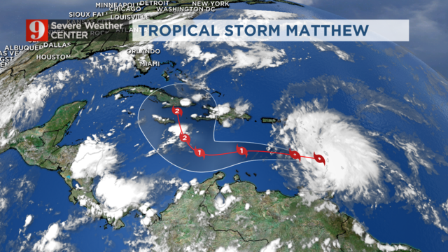
Matthew continues with maximum sustained winds of 60 MPH, and it travels west at 18 MPH.
Same general trajectory is expected through Saturday, and slowing down. Matthew will linger around the southern Caribbean before it turns to the north.
Latest: #Matthew 5pm advisory. Should become a large hurricane, over 100mph winds by late weekend. Updates on #wftv pic.twitter.com/nZOASkvIVm
— tom terry (@TTerryWFTV) September 28, 2016
How far east or west, or how close to Florida will it get? We will just have to wait and see. There are 3 full days for the storm to travel slowly and feed off the warm Caribbean water.
There is also the land factor. If travels over the southeastern portion of Cuba, it will be interacting with the tall Cuban Range known as Sierra Maestra, which will make it lose some punch.
Chief Meteorologist Tom Terry is on Channel 9 until 6:30 p.m.
Also, Matthew is a very wide system. The cloud field extends about 250 miles from its center. Tropical storm force winds extend out to 205 miles from its center, mainly to the northeast.
Tropical storm force winds are expected to affect the southern Leeward Islands and northern windward island through Tuesday evening.
A tropical storm warning is in effect for Guadeloupe and Martinique, St. Lucia, Dominica, Barbados, St. Vincent, and the Grenadine Islands. Bonaire, Curacao, Aruba should monitor Matthew closely.
The government of the Netherlands has issued a Tropical Storm watch for Bonaire. Curacao and Aruba are also under a Tropical Storm watch.
Tropical watch is in effect for Bonaire, Aruba Curacao. Tropical warning for most of the Lesser Antilles. #Matthew pic.twitter.com/AQFWlqShEV
— Irene Sans (@IreneSans) September 28, 2016
Rainfall amounts between 4 and 8 inches are possible across the Windward Islands and southern region of the Leeward Islands through Thursday. Such heavy amounts could produce life-threatening flash floods and mud slides.
The U.S. and British Virgin Islands and Puerto Rico can expect between 1-2 inches of rain.
Although it is expected to travel well south of Puerto Rico, the system could still bring significant wave height increase above 15 feet and rough seas over the offshore waters south of Puerto Rico.
“As expected, Tropical Storm Matthew formed in the Atlantic. It will be traveling over the southern Caribbean during the rest of this week. It will most likely strengthen into a category 2 hurricane. After that, it will be close to Cuba this weekend. From there, it is too early to tell where it will go. We are in the heart of the hurricane season, so we need to pay close attention to this storm,” WFTV Channel 9’s Meteorologist Brian Shields said.
RECEIVE WEATHER ALERTS IN YOUR CURRENT LOCATION, RIGHT TO YOUR PHONE
Our team of meteorologists will continue to monitor Tropical Storm Matthew closely and bring you updates about its evolution on WFTV Channel 9, WFTV.com, the WFTVWeather app and on all of our social media platforms.
Follow our Meteorologists:
© 2016 Cox Media Group.
Leave a Reply